1/7


India Satellite Weather
4K+ดาวน์โหลด
4.5MBขนาด
5.0.6(27-01-2020)เวอร์ชั่นล่าสุด

รายละเอียดรีวิวเวอร์ชั่นข้อมูล
1/7
คำอธิบายของIndia Satellite Weather
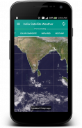
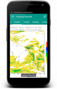
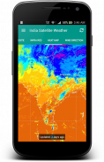
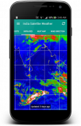
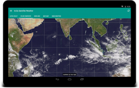
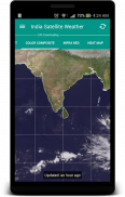
"ภาพที่มีค่าพันคำ". ข้อมูลสภาพอากาศที่ซับซ้อนสามารถสื่อความหมายได้อย่างง่ายดายด้วยแผนที่ภาพ โดยการสังเกตเมฆก่อตัวรอบเมืองของคุณคุณสามารถคาดการณ์ได้ว่าวันนั้นจะเป็นร้อนหรือฝน / มีเมฆปกคลุม
มันเป็นอุปกรณ์ที่ดีมากที่มีความสามารถแคชข้อมูลและจะไม่ดาวน์โหลดข้อมูลที่ซ้ำกันจากเซิร์ฟเวอร์ ดาวน์โหลดแผนที่อากาศจะเก็บไว้ในเครื่องและสามารถเข้าถึงได้แบบออฟไลน์
โปรแกรมนี้จะเรียกสภาพอากาศแผนที่โดยตรงจากอินเดียกรมอุตุนิยมวิทยา (www.imd.gov.in) และ CIMSS [สหรัฐอเมริกา] (http://cimss.ssec.wisc.edu)
FYI: ฉันจริงๆไม่ได้มีการควบคุมเกี่ยวกับการหายตัวไปของภูมิภาคทางตอนเหนือของอินเดียประเภทแผนที่เพราะพวกเขามีให้โดยสหรัฐอเมริกากรมอุตุนิยมวิทยา
นี้เป็นโปรแกรมที่มาเปิด: https://github.com/Shahul3D/IndiaSatelliteWeather
รู้สึกอิสระที่จะมีส่วนร่วม!

รับประกันแอปดี!แอปนี้ผ่านการทดสอบความปลอดภัยด้านไวรัส มัลแวร์ และสิ่งโจมตีอื่นๆ
และไม่มีสิ่งคุกคามใดๆ
India Satellite Weather - ข้อมูล APK
เวอร์ชั่น APK: 5.0.6แพ็คเกจ: com.shahul3d.indiasatelliteweatherชื่อ: India Satellite Weatherขนาด: 4.5 MBดาวน์โหลด: 1.5Kเวอร์ชั่น : 5.0.6วันที่ปล่อย: 2024-05-17 22:51:38หน้าจอขั้นต่ำ: SMALLCPU ที่รองรับ:
ID ของแพคเกจ: com.shahul3d.indiasatelliteweatherลายเซ็น SHA1: 11:AF:15:5C:61:48:34:41:49:44:ED:AF:7F:FC:74:0F:86:6D:2C:2Bนักพัฒนา (CN): ShahulHameedองค์กร (O): ท้องถิ่น (L): Trichyประเทศ (C): INDIAรัฐ/เมือง (ST): Tamil Nadu
เวอร์ชั่นล่าสุดของIndia Satellite Weather
5.0.6
27/1/20201.5K ดาวน์โหลด4.5 MB ขนาด
เวอร์ชั่นอื่น
5.0.5
29/11/20191.5K ดาวน์โหลด4.5 MB ขนาด
5.0.2
28/6/20181.5K ดาวน์โหลด4.5 MB ขนาด
4.4
24/3/20171.5K ดาวน์โหลด4.5 MB ขนาด
4.3
2/3/20171.5K ดาวน์โหลด4.5 MB ขนาด
4.2
16/12/20161.5K ดาวน์โหลด4.5 MB ขนาด
4.1
6/6/20161.5K ดาวน์โหลด4.5 MB ขนาด
3.3.1
10/5/20161.5K ดาวน์โหลด4.5 MB ขนาด
3.3
23/12/20151.5K ดาวน์โหลด4.5 MB ขนาด
3.2
16/6/20151.5K ดาวน์โหลด4.5 MB ขนาด


แอปในประเภทเดียวกัน


English


